Hiking the North Country Trail: Lost Nation along Baw Besse Trail to Hillsdale
- Deborah Guthrie

- Apr 21, 2021
- 3 min read
Updated: Apr 22, 2021

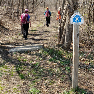
For those of you hiking the North Country National Scenic Trail, this section is located in Southern Michigan, HIllsdale County where I began my hike at the Ohio Michigan border. The North Country Trail is over 4,600 miles across eight states with Michigan having the longest stretch of 1,100 miles. Each weekend I have free, I am committed to hiking the trail, discovering Michigan towns, and meeting new people along the way.

Signing Trailhead Book before leaving Lost Nation on M-34.

Ember & Ash Social unplugs on the weekend and goes social wherever we discover new places to explore in our digital world.

The digital world is how I discovered the North Country Trail and why I hike. I'm so glad I'm committed to this too because I'm discovering so many new things, with the online social connections I've made, that I would have never known before like being able to identify different types of vegetation and trees like these:

Skunk Cabbage

Milkweed

Shagbark Hickory Tree

Chicken of the Woods - Mushroom
Before I leave the Lost Nation section of our hike, I want to share an update on a section of our hike we did three weeks ago from the NCT Baw Besse Chapter. As part of earth month, Chapter volunteers fixed one of the water crossings so that it is no longer bouncy. When we crossed it, one of our hikers mentioned how unstable this crossing felt and I was happy to see a post on the Chapter's Facebook Page sharing that they fixed it and it is no longer wobbly.
Our crossing:

The fix from Baw Besse Facebook post:

See all their pics from this update: Chief Baw Besse Chapter
This crossing is over the Otto Drain near M-34. Crossing M-34 onto Chase road you come across a row of Osage Orange Trees.


I only know what they are because of my fellow hikers who explained how farmers used these trees along the edge of their farm as fences due to how the vines and thorny branches would form a natural fence.

They also explained that the fruit from these trees, while edible, is very bitter and not like an orange at all. Most people try and toast the seeds but getting to them and the process is difficult. There were several of these oranges (pic above) on the ground along the roadway. I took one look at these oranges that definitely looked like brains and thought I'd never even try!

Once you turn on Beecher Rd., you come across the small town of Osseo and a section of the trail that takes you off the paved roads and onto a meadow trail before connecting with the BAW Besse Trail. This was a beautiful section of the trail.


Trail sites I researched state that this is an 8.2 mile rails to trail asphalt trail yet starting at Lacy Street in Osseo, the trail begins as a meadow trail. Maps indicate it is BAW Besse trail so I wonder why the discrepancy in trail map descriptions. I wish I could remember where it transitions into asphalt. If you know, please comment below.

Once you come upon Baw Besse Lake, you can see why this area is more trafficked as the NCT has several sections of trail that connects with other trails through cities and towns in more populated areas. At this point, my thighs were burning and I literally took tons of photos as an excuse to rest my poor legs. This was the longest hike I had been on and my thighs were definately telling me that.


The inviting beach and benches at the park were definitely calling to me. Lots of families and couples were out for a walk and relaxing by the water as the day was beautiful. I notoriously have a picture with no one in it!

Some sort of flies were out to in full force and I was glad I had a hat, hoodie and mask on! I was swatting in front of my face from the beach area until we reached our car. If it weren't for the flies, that bench in the picture below was really calling me to rest until the sun went down! Not sure how long it would've taken me to get up if I had sat down. This area is popular and I can see why. It is very well maintained and a beautiful spot for the community.


This hike was a fantastic representation of how your walk can take you through a beautifully wooded and hilly more serene area to a more populated and flat recreational area with a lake and sandy beach. It's amazing the difference in terrain you can walk through all on a day's hike.

Deborah Guthrie is a weekend adventure blogger leaving a digital footprint that ignites the spark within others to explore the world outdoors. Follow her blogs on Ember & Ash Social.

Comments